To provide you with the best experience, cookies are used on this site.  Learn more

Allow cookies

Eilean Dhomhnaill, Loch Olabhat

Griminish, Isle Of North Uist, Outer Hebrides, HS6 5BX

Type:Monuments & Ruins

Add Eilean Dhomhnaill, Loch Olabhat to your Itinerary

Product Image

Book Tickets Online

About

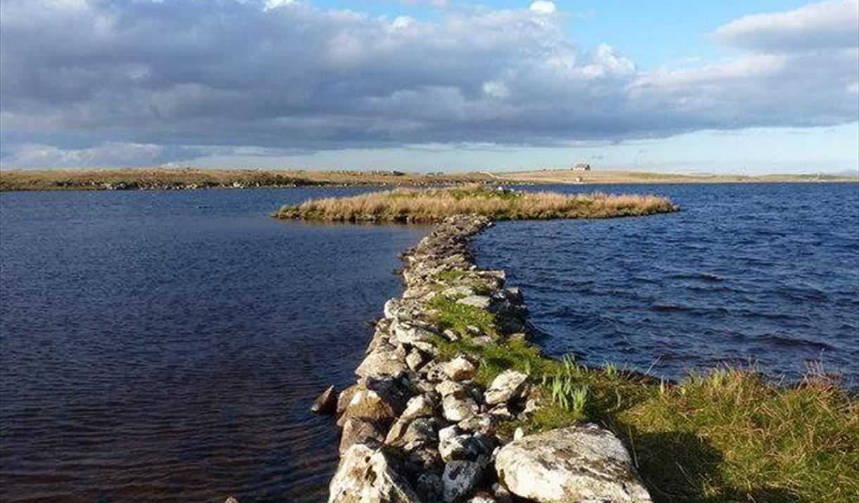
Image: The causeway to the settlement in Loch Olabhat © Copyright Richard Law and licensed for reuse under this Creative Commons Licence.

During at least its later period of occupation it was connected to the shore by a timber-built causeway. The settlement on it had a long and complex history, which has been revealed by extensive excavations in the late 1980s, except for the earliest, more inaccessible waterlogged phases.

Settlement began when the water level in the loch was much lower than today, and consisted of a series of houses, with ancillary buildings, rebuilt on the same spot over a long period of time. The later houses built on the islet were enclosed within a timber and stone wall. Each successive dwelling was built of stone or turf, and was rectangular or oval in shape, 5-6 by 3-4 metres in size, and accompanied by a series of outhouses. The interior of the main building was subdivided, and there was a central hearth defined by cobbles or paving. Large quantities of domestic waste (principally comprising organic material and pottery) was recovered from across the settlement, and it was through this accumulation of debris, together with the collapsed remains of the buildings, that the islet grew higher and so evaded the rising waters of the loch. Eilean Domhnuill can only be viewed form the loch edge.

Eilean Olabhat is located on a promontory on the south side of the loch (NF 7498 7528). Excavations on the small summit of the promontory show that it was occupied by first Iron Age and then early medieval buildings. The latter was a multi-cellular roofed building dating to the 6th to 7th centuries AD. In its final phase, it contained a hearth and fragments of moulds and crucibles associated with working bronze and perhaps other precious metals. The moulds were used for making personal ornaments such as pins and brooches, possibly representing reoccupation of the building by an itinerant bronzesmith who fashioned jewellery for those living in nearby high-status settlements.

Map & Directions

TripAdvisor

Recently Viewed

  1. Seal Viewing Point

    Type

    Wildlife, Safari Parks & Zoos

    Seal viewing point

  2. Airigh Mhic Ruairidh

    Type

    Self Catering

    Imagine walking into a place that makes you feel welcome, spoilt and at peace. A place that allows…

  3. Salar Smokehouse

    Type

    Producers & Specialist Shops

    Salar Smokehouse opened as a small business in South Uist in about 1987, with the original owner…

  4. Moorcroft Holidays

    Type

    Camping Park

    We have 12 hard standing pitches with electric hook up for motorhomes, campervans and caravans, 10…

  5. Hebridean Holiday Cabins

    Type

    Camping pods

    Hebridean Holiday Cabins are brand new for 2020, and are the perfect choice for a relaxing holiday…

  6. West Harris Trust Campervan Hook-ups

    Type

    Camping Park

    Located in a central location, our hook-ups offer the ideal base for exploring all Harris has to…

What's Nearby

  1. The Outer Hebrides are an exceptional place to see this iconic bird, hosting one of the…

    0.31 miles away
  2. Scolpaig Tower is a Georgian folly located near the village of Scolpaig.

    1.04 miles away
  3. The folly was built on the site of an Iron Age broch by Dr Alexander Macleod in the…

    1.06 miles away
  1. Kilpheder Cross

    1.52 miles away
  2. St Kilda archipelago can be viewed from the west coast of North Uist. The viewpoint is…

    2.19 miles away
  3. Vallay is a beautiful desserted tidal island and is accessible at low tide from Sollas.…

    2.29 miles away
  4. Hosta beach is easily accessible from the main road at Hosta.

    2.39 miles away
  5. At this site, situated on the southern slope of the hill, lie the remains of a Neolithic…

    2.88 miles away
  6. Drawings, paintings in oil,watercolour and mixed media; original prints; etchings; hand…

    3 miles away
  7. Malacleit is a peaceful crofting village situated on the edge of Traigh Bhalaigh (Vallay)…

    3 miles away
  8. Igot2travel offer wildlife watching, cultural & history, walking, fishing and…

    3.01 miles away
  9. A beautiful reserve on the north west coast of North Uist with sandy beaches, rocky…

    3.4 miles away
  10. This dumpy looking finch with prominent white flashes in the wing can often be found on…

    3.54 miles away
  11. The Cuckoo is often seen along the fence running along the edge of Ben Risary plantation.

    3.59 miles away
  12. Sollas beach is a stunning white sandy beach and eaily accessible from the village of…

    3.69 miles away
  13. Corncrakes are related to moorhens, coots and rails but differ from most members of the…

    3.84 miles away
Previous Next

My Planner

You can build your own holiday itinerary here! Just browse our site and click this button to add to your itinerary when you see something you like. If your planner is not finished, simply click save and you can come back to it later on! You also have the option to send your itinerary to our tailor made holiday partner.

Places to Eat

Our Islands