About
Image 1: https://www.instagram.com/_kfarmer/
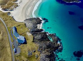
This is an established trail with way-marker posts. It has a combination of cultural and natural heritage which gives a great insight to the island’s past and present. It has also some truly spectacular scenery.
The walk begins and ends at the gate across the road from the telephone kiosk at Tangasdale - approximately 1.7 miles / 2.75km west from Castlebay on the A888. There is an area near the gate which is suitable for parking. The walk leads out as far as Dun Ban, an Iron Age fortification approximately 2,000 years old. Other historical and archaeological sites to be seen are a 15th century tower, an 18th century settlement area and a 4,000 year old Bronze Age burial cairn.
Map & Directions
- The walk begins and ends at the gate across the road from the telephone kiosk at Tangasdal
- Once through the gate follow the marker posts leading to Loch Tangasdal. Continuing down to the loch you go through a second gate and Macleods Tower which you will see in the middle of the loch.
- There is a stile across the fence and a footbridge leading over a stream. Once over the stream, approximately 300m on, you will arrive at the remains of an old settlement.
- Dun Ban. From the Dun retrace your steps back to post 15. The route branches here, giving a choice of returning by the original path or an alternative route via the beach.


