On Lewis, even Callanish never really gets that busy but if it’s true isolation you’re after, the areas of Lewis to the southeast and northeast of Stornoway will be just what you are looking for.
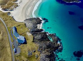
The northeast of the island has a stunning, remote coastline made accessible by the dead-end B895, where townships such as Back (Bac) are quieter but offer elemental scenery, walking and wildlife spotting. Back overlooks the appositely named Broad Bay and the road continues north before petering out as it crosses the Stone River high above beautiful Tràigh Ghearadha, popularly known as Garry Beach. The river is traversed by the Bridge to Nowhere, a stony track accessible only to walkers and peat cutters. The adventurous hiker could follow the narrow track along the coast all the way to Ness, a distance of 11 miles.
Alternatively, head east out of Stornoway along the A866 through the Eye peninsula (known colloquially as Point) which is connected by a membrane of land to the rest of Lewis. A short diversion takes you to the plaque dedicated to the Iolaire disaster, while the main road continues past the airport and crosses an isthmus barely 100m wide. On its far side you’ll find the chilling remains of the church of St Columba (Eaglais na h-Aoidhe), one of Lewis’s great unsung treasures. This is the burial ground of the Macleod chiefs, and 19 are said to lie here. Reflecting their importance, the tombs are astonishing, with bas-reliefs of warriors and a chiselled cabarfeidh (stag’s head).
Journey’s end on Point is Tiumpan Head and its lighthouse, where the road sweeps uphill rather like a ski jump, and for a second you may wonder if you are about to leap into the sea. This is an excellent place to watch for Minke whale and Risso’s, white-beaked and common dolphins, and the location is rightly on the Hebridean Whale Trail.
Much of southeast Lewis is given over to a vast expanse of land known as the North and South Lochs and the Pairc (those headed for Harris will see this landscape to their left). The South Lochs have some of the most attractive small villages on Lewis, a traditional and vibrant Gaelic-speaking community and great wildlife-watching opportunities. The coastline is spectacularly rocky and indented with deep lochs that have something Norwegian about them such as Loch Erisort and Loch Leurbost, graceful fingers of sea water that cuts deep into the coast. The hub of this loch-studded area is the township of Kershadar (Cearsiadair), 6 miles from the A859, where you will find an excellent museum, café and visitor centre. From the village of Cromor you have unimpeded views across the Minch
The Pairc, meanwhile, is one of the unsung jewels of Lewis, the island’s ‘Empty Quarter’. Lying southeast of Loch Sheld, it comprises an incredible 168,000 acres. The single unclassified road that winds through the Pairc is one of the most depopulated moorland tracks you will encounter in the UK and passes over the lonely, narrow headwaters of Loch Seaforth.
One piece of advice: a cursory glance at a road map of Lewis might suggest you could cover the Lochs and the Pairc in a couple of hours. Don’t fall into that trap! The roads are narrow and slow and there is much to see, so combining exploration with a visit to the Ravenspoint Centre at Kershadar will take the best part of a day.
Written by Mark Rowe who is the author of Outer Hebrides, published by Bradt. The guide includes in-depth coverage of the areas featured in this article in depth as well as a detailed chapter on every inhabited island of the Outer Hebrides.


Comments
Comments are disabled for this post.