Epic Landscapes in the Outer Hebrides
The Outer Hebrides are unlike anywhere you’ve ever been before.
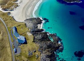
200 kilometres of moorlands, mountains, machair and sweeping sandy beaches. All on Europe’s oldest rock, Lewisian Gniess.
Home to otters, crofters, eagles, orcas and deer, the Outer Hebrides map is magical. A landscape defined by ice, wind and ceaseless Atlantic pounding. So, if you’re looking for a captivating island escape, look no further.
Amongst the epic landscape and amazing wildlife, you will discover that each of the islands has its own unique geography and personality.
To the north and you have the island of Lewis and Harris, the largest island in Scotland. Lewis with its wonderful and distinctive archaeology, atmospheric moorland, exquisite beaches, peat bogs and a myriad of Lochs and Lochans. Many lochans are covered in white waterlilies in the summer and in late summer the moors turn heather-purple.
Travel south you cross the majestic, rugged hills of North Harris where eagles soar, and cross over by bridge to the isle of Scalpay. Before descending towards the shores of magnificent white shell sand beaches. Here you will also find some of the fertile plains that form the machair, turning a riot of colour in the summer with its wild coastal flowers.
Crossing the sound of Harris, you arrive on the Isle of Berneray which has a mix of rocky little bays on the east coast and extensive machair and sandy beaches on the west.
A short drive across the causeway and you arrive on North Uist where the rocky inlets along the east coast meets the stunning wildlife-rich grasslands of the machair and beaches of the north and west coast. The island is heavily indented with very scenic sea lochs and sheltered natural harbours.
The Isle of Benbecula is by contrast a very flat island and is the most populated island in Uist. It is also home to a great deal of birdlife on the machair and scenic beaches on the west coast.
South Uist is a striking long, narrow island with rugged hills on the east and almost continuous machair and brilliant white sand beaches on the west. Set between the mountains and the sea lies traditional managed crofting land. Eriskay is reached by a causeway from South Uist and is a rocky little island with a strong fishing heritage.
Barra has all of the above in minature. Its remarkable scenery is a delightful mix of rugged hills, rocky coves and flower covered machair. Vatersay is a beautiful little island dominated by machair and wonderful shell sand beaches.
The Island’s Islands
The Shiant Islands are ancient volcanic stacks, home to the puffins, guillemots and fulmars in one of Britain's largest seabird colonies.
St Kilda is a UNESCO World Heritage site of 3 main islands, flanked by dramatic skerries and stacks. Pink and white granite on the east. Brown and black to the west.
St Kilda is like geological neapolitan ice cream and home to the U.K’s tallest sea cliffs.
Mingulay is a smaller version of St Kilda, but no less dramatic.
Follow us on instagram @visitouterhebrides and share your favourite pics using #visitouterhebrides


